Overberg
(Department of Cultural Affairs & Sport, Western Cape Government)
| The name means "over the mountains" - the Hottentots-Holland mountains. The area was explored by VOC traders and explorers and soon land was given out to farmers who settled there. With an abundance of land available on the frontier no free person wanted to work for someone else. The rapid expansion of the colony meant that slaves were also brought into the new areas. Older male slaves were dispersed among frontier regions on loan farms (the areas of extensive farming) where they worked as herdsmen. Slave auctions were held at Caledon and Swellendam. From the days of the Khoekhoen herders, this area had been a stock farming region. Many of the mission stations founded in this area exist today, for example Genadendal, Elim, Herbertsdale, Slangrivier, Suurbraak, Middleton and Teslaarsdal. |
|
||||||||||||||
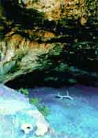
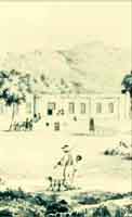
Hangklip (R44, False Bay coast) Runaway slaves from Cape Town would hide out on Table Mountain and slaves from Stellenbosch fled to Cape Town, or tried to reach a group of escapees who survived for many years at Cape Hangklip. In 1709 a slave, Jacob Smith, organised a large-scale desertion from the Stellenbosch district. Forty-five slaves escaped and got as far as Swellendam where they were recaptured or returned voluntarily to their owners. A placaat of 1714 proclaimed that any slave who had been at large for three days or more and who resisted capture could be shot on sight by a colonist. In 1715 the Landdrost and Heemraden of Stellenbosch sought permission to cut the Achilles tendon of runaways. Hot springs at Caledon Casino, Hotel and Spa (N2) The Khoekhoen called the hot springs "dispore kamma" meaning "warm water". In 1708 land around the springs was granted to Ferdinand Appel on condition that he provided bathing facilities for people. Slaves worked here and rested, using their own facilties. |
|||||||||||||||
|
 Teslaarsdal |
||||||||||||||
 Middleton |
|||||||||||||||
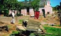
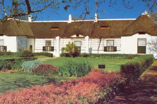
Teslaarsdal (R326) Johannes Jacobus Tesselaar was a wealthy landowner in the Overberg. He left an estate in1797 of five farms, 14 male slaves, four female slaves, 125 horses, 60 head of cattle and 500 sheep. Tesselaar left the farm Hartebeesrivier to some of his slaves. Direct descendents still own parts of the farm today and the settlement called Teslaarsdal developed on this farm. Remnants from that period are still visible, and in the graveyard there are graves from descendents Coert, Gertse, Huizenberg, Bredenkamp, among others. Genealogical research has been done by the Caledon Museum. |
|||||||||||||||
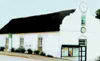
| Middleton (N2) The Middleton community was established in 1850 with the presentation of land (glebe land) by the Anglican Church to its members, some of whom were of slave descent. Genealogical studies were undertaken by the Caledon Museum. | |||||||||||||||
|
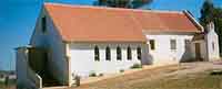
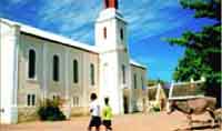
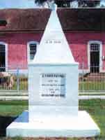
Moravian Church started its first mission station at Baviaanskloof, later known as Genadendal, to work among the Khoekhoen of the region. After emancipation, slaves settled at the mission station. Today's visitors to the "Mission-werf" (yard) can see the church, fine examples of architecture from the period, a working water mill and printing works. Moravian Church, GenadendalElim (R317) This mission was founded in 1838 after the Moravian Missionary Society acquired the farm Vogelstruyskraal near Cape Agulhas in the Caledon district. The newly-established mission became known as "Elim" after the fountains in the area (Exodus 15:27). The only Slave Emancipation Monument in South Africa can be seen in Church Street near the church. |
|||||||||||||||
|
|||||||||||||||
Napier (R316) Napier was founded in 1838 after the farm Klipdrift was bought from Pieter de Bruyn. Feeshuis 150, a building next to the Dutch Reformed Church (part of the churchyard), was a wine cellar but was also used to house slaves. It was restored for Napier's 150th anniversary festival in 1988. A key is available at the church office. Struisbaai (R319) In 1766 the VOC hooker (a single-masted ship) Meermin was returning to the Cape with 140 Madagascan slaves and weapons. The slaves, who were told to clean the weapons, seized the opportunity to take over the ship. Without navigation skills the slaves had to make use of the crew. The crew fooled them by sailing in the direction of Madagascar by day and to the Cape by night until they dropped anchor in Struisbaai. A few of the slaves went ashore where they were captured by local farmers. The remaining slaves became suspicious and in the resulting skirmish with the crew, the captain ordered the anchor cables to be cut. Three sealed bottles containing messages were thrown overboard. The ship ran aground soon afterwards, and the rest of the slaves were captured. One of the messages that were thrown overboard is housed in the Cape Archives Repository. |
|||||||||||||||
|
|||||||||||||||
|
The Drostdy (Swellengrebel Street) This was built between 1746 and 1747 using slave labour. The old wagon shed on the Drostdy museum grounds was used as slave quarters from 1814 to 1834. The Old Goal dates from the same period as the Drostdy, and is also presumed to have been built by slaves. The Drostdy Museum is also in possession of compensation receipts issued to slave owners. Oefeningshuis (Voortrek Street) The Oefeningshuis was erected in 1838 with the aim of providing religious training and education to emancipated slaves and "heathens". It now houses the Tourism Bureau. Suurbraak (R324) This quaint village nestles in a valley at the foot of the Langeberg Mountains. Before Suurbraak was established as a mission station in 1809, it was occupied by the indigenous Attaqua people who called the settlement "Xairu" - "a place of beauty". The London Mission Society established a station here in 1809 and the cottages were built by those who accepted Christianity. The first missionary was a person called Seidenfaden, invited there by Hans Moos, the leader of the local Attequas. The church was built around 1835. Slaves settled here after emancipation. The first church, parsonage, school, old houses and buildings around the village square have been restored and are in use, as is the Anglican church. All are situated on the main road through the town. |
|||||||||||||||
|
|||||||||||||||
|
We are pleased to share with you that the Western Cape Government (WCG) has once again achieved certification as a Top Employer in 2024. |
||||
 |
Western Cape Government © 2023. All rights reserved.
This project is an initiative of the Western Cape Government. |
 |